
Myths vs. Facts about Village Farms Davis
by Alan Pryor
I. INTRODUCTION
Opponents of Village Farms Davis have made numerous misleading and/or outright false claims about the Project and its supposed adverse environmental impacts on Davis and its residents. Their allegations are made without almost no quantitative supporting data from independent, verifiable 3rd-party sources to support their claims. Unfortunately, these naysayers instead rely on speculation and innuendo to attempt to disparage and denigrate the proposed Project.
This article is the first in a series that will present detailed information that factually refutes each of these untrue “myths” and false allegations made by project opponents . This first article summarizes the false claims and provides a brief summary response followed by a more in-depth discussion refuting some of the allegations that require additional information to refute them. Subsequent articles in the coming weeks will further address some of these false claims in much greater detail.
II. SUMMARY OF MYTHS AND FACTS
A. Alleged Risks of Flooding
Myth No. 1 – “The Project is partly in a FEMA 100-year floodplain that results in huge onsite flood risks for future residents!”
Fact No. 1 – This is a red herring argument. In fact, the Project is engineered to meet FEMA 200-year floodplain protection standards making it one of the most flood-resilient neighborhoods in Davis. FEMA must certify the lots before construction so that flood insurance will not be required by future residents. (see Further Discussion section below for additional information)
____________________
Myth No. 2 – “The Project will cause enormous downstream flooding impacts endangering homes and residents in Wildhorse!”
Fact No 2 – There is not now, nor will there ever be, ANY future runoff from the Project onto Wildhorse Golf Course . Any runoff from the Project will instead be directed north to a detention basin away from the channel which otherwise only conveys flood waters from west and north Davis through the North Covell Ditch to the Wildhorse Golf Course. (see Further Discussion section below for additional information)
____________________
B. Alleged Risks of Toxic Contamination from Landfill and Soils
Myth No. 3 – “Toxic contamination from the nearby Old Davis Landfill endangers future residents of the Project”
Fact No. 3– Almost all of the contamination detected in the past in the groundwater beneath the Landfill and the Project has long since dissipated. The California Regional Water Quality Control Board has confirmed in a letter to the City that the groundwater beneath the Project will present “no risk” to Project residents that will otherwise only use Davis municipal water supplies. (see Further Discussion section below for additional information)
____________________
Myth No. 4 – “PFASs (“forever chemicals”) detected in groundwater under the Project will seep into Channel A and flow out through Wildhorse Golf Course into Willow Slough and the Yolo Bypass Endangering the Vic Fazio Wildlife Refuge!.”
Fact No. 4 – Village Farms Davis will actually provide increased protection from PFAS infiltration into Channel A. The current Channel A is unlined which theoretically could allow PFAS to enter the Channel – but only if groundwater rises significantly higher than ever before recorded. The new Channel A depth will be deeper but still substantially above the maximum water table ever recorded. Plus the new Channel will be lined with an impervious compacted clay layer to prevent any infiltration of groundwater into the Channel. (see Further Discussion section below for additional information)
____________________
Myth No. 5 – “Children will be exposed to the pesticide Toxaphene and Lead in Soil in the Project’s Future Community Park endangering their future health!”
Fact No. 5 – These contaminants were located in only a few discrete locations on the soil surface near the old homestead on the property. But Project opponents fail to disclose that complete removal and remediation of these discretely localized contaminants will be performed under the auspices of and certified by the California Department of Toxic Substances Control to non-detectable levels before commencement of any construction. After removal, the entire site will be completely free of these contaminants.
____________________
Myth No. 6 – “The entire Project site will be contaminated with very high levels of arsenic brought in with the soil from the Agricultural Transition Area to the north of the project putting future residents at risk!”
Fact No. 6 – Extensive soil testing (down to 10 ft) in the Agricultural Transition Area show background concentrations of naturally-occurring arsenic average 7.0 mg/kg (ppm). These concentrations are actually slightly less than average arsenic concentrations of 7.1 mg/kg found in the Project site. Further, arsenic concentrations at both sites are actually substantially less than reported regional soil arsenic concentrations (at an average of 10.0 mg/kg) and thus present no risk to future residents of the Project.
_________________________________________
C. Alleged Traffic and Public Transit Adverse Impacts
Myth No. 7 – “Huge traffic increases on Poleline Rd and Covell Blvd. will cause massive traffic jams imperiling bicycling safety.”
Fact No. 7 – Of course, any large development will bring increased traffic impacts as will Village Farms Davis once it is built out in 15 years +/-. However, the central location of the Project is within easy walking or biking distance of many destinations thus minimizing future commuting and intra-city automobile traffic. And there are 18 public bus stops near the Project which minimizes future commuting and intra-city automobile traffic.
Nugget shopping center is directly across the street. There are four K-12 schools within ¾ mile. Downtown and UCD are each about 1.5 miles away. As a result, there is no other location in the City that offers this many public transit options and close proximity to so many local destinations. This central location of the Project with so many public transit and biking options results in less traffic and biking impacts than if 1,800 units were otherwise built anywhere else in the City. (see Further Discussion below for additional information)
__________________________________________
Myth No. 8 – “The Project will not have any grade-separated crossings of Pole Line Road and the railroad tracks at F St.!”
Fact No. 8 – There will be Grade-Separated Crossings both under Poleline Rd. and over F St. Village Farms Davis will entirely pay for the below-grade crossing under Poleline Road landing near Nugget Fields. For the over-crossing of F. St, the project will provide the land on the project site, fund the design and engineering, and pay for the project’s “fair-share” cost of the over-crossing construction with a landing near Northstar Pond.
___________________________________________
D. Alleged Adverse Impacts on Habitat
Myth No. 9 – “The Project will destroy valuable wetland habitat endangering rare plants and animals!”
Fact No. 9 – The Project will preserve approximately 47.1 acres of alkali playa and wetland habitat with a permanent conservation easement and perpetual endowment. This includes the associated watershed and a buffer to protect it from development impacts. This feature will be developed in coordination with qualified conservation/land trust organizations and according to explicit guidelines of the California Department of Fish and Wildlife. There has NEVER been a development project in Davis that has dedicated this much land to native habitat.
__________________________________________
Myth No. 10 – “The Project will permanently destroy a thousand trees along Channel A that provides critical habitat for animals!”
Fact No. 10 – The FEIR discloses a total of several hundred trees along the existing Channel A that will be removed of which only 45 are native. Most of the trees are otherwise aged and decrepit and nearing the end of their natural lives. However, all removed trees will be be replanted with drought-resistant species per City requirements. And approximately 3,600 additional new drought-resistant trees will be planted throughout the entire project. This will result in a huge increase in the overall number of trees thus greatly enhancing the urban forest.
_____________________________________________
E. Alleged High Housing Costs and Deficiencies in the Affordable Housing Plan
Myth No. 11 – “The minimum cost of a new home at Village Farms will be $740,000. Only very well-to-do purchasers will be able to afford to live there!”
Fact No. 11 -This is a complete fabrication. As Project opponents are well aware, the supposed “minimum” estimated sales price they tout is actually the “average” cost of a home sold in Davis in 2025. In fact, there are about 1,000 lots in the project that will be less than 5,000 sq ft on which hundreds of townhouses and smaller homes/duplexes on the order of 800 – 1,400 sq ft will be constructed.
These smaller lots are specifically designed for first-time home buyers. Of these smaller lots, at least 10% will be for attached townhouses expected to be between 800 and 1,000 sq ft. The remaining lots can either be half-plexes or stand-alone single family units and are expected to range from 1,000 – 1,400 sq ft each.
Assuming the same $425/sq ft sales price as used in the City’s economic analysis described above, the 800 – 1,000 sq ft townhouses would cost less $425,000 and the 1,000 – 1,400 sq ft half-plex/single family homes would range in price from $425,000 to $637,500.
These prices are thus far less than the fictitious “minimum” price of $740,000 otherwise erroneously touted by project opponents. (see Further Discussion below for additional information)
__________________________________________________
Myth No. 12 – “The 360 dedicated low-income housing units will probably never be built because there are no guarantees that the developer must construct them!”
Fact No. 12 – The proposed permanently affordable, subsidized rental apartments represent 20% of the total 1,800 units for the project. It is supported by an irrevocable 16-acre donation of land and an additional $6 million contributed to the Davis Housing Trust Fund to support construction. This donation is, by far, the largest contribution ever to low-income housing by any developer in Davis. This current customized Low Income Housing Plan is fully compliant with the City’s Low Income Housing Ordinance and was specifically demanded by the City because they believe it has the highest probability that the affordable housing units will actually be built.
______________________________________________________
III. FURTHER DISCUSSION OF SELECT MYTHS AND FACTS
The following discussion contains more detailed information refuting some of the false allegations made by opponents of the Projectthat are discussed more briefly above
A. Alleged Risks of Flooding
Myth No. 1 – “The Project has Huge Onsite Flood Risks because it is partially in a FEMA 100-year Floodplain!” – Opponents claim a portion of Village Farms Davis is in a FEMA 100-year floodplain which will undoubtedly flood in the future exposing the City to huge liabilities and require homeowners to pay huge flood insurance premiums.
Fact No. 1 – In fact, opponents are fully aware that the Project will meet FEMA 200-year flood protection standards before construction even begins . While a portion of Village Farms is currently in a FEMA 100-year floodplain, the site will be engineered to provide protection for a 200-year flood event as now required by State law. All lot elevations will be certified by FEMA prior to authorization of construction and NO FEMA flood insurance will be required for any homes.
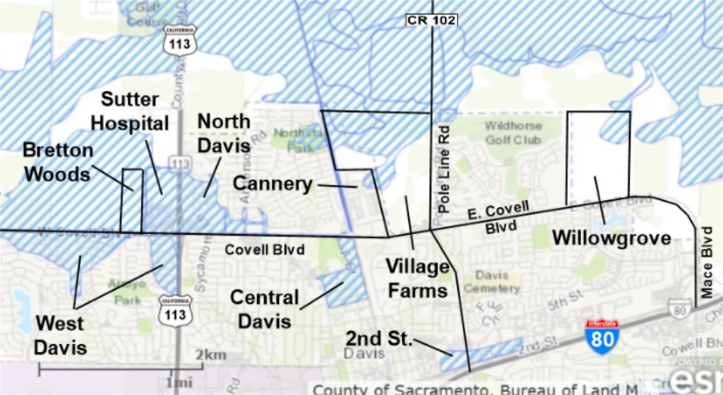
As a result, Village Farms Davis will actually be more flood-resilient than almost all other subdivisions in Davis. Indeed, there are currently over 400 acres of existing housing in Davis that are still in the FEMA 100-year floodplain map including substantial areas in west, north, and central Davis as shown in the following map (the 100-year floodplain is shown in blue cross-hatching).
______________________________________________________
Myth No. 2 – “The Project will cause enormous downstream flooding impacts endangering homes and residents in Wildhorse!” – Project Opponents Falsely Claim the Project will Result in Increased Run-off Flow under Poleline Rd onto the Wildhorse Golf Course Causing Flooding and Endangering Homes and Residents in the Adjacent Wildhorse Neighborhood.
Fact No 2 – There is not now any runoff from the Project into Wildhorse nor will there be in the future. Project opponents are well aware of the fact that Village Farms Davis does not now & will not in the future convey any runoff water from the project into Channel A and on into the Golf Course. The Project is engineered to maintain existing flow conditions in Channel A and all runoff from the Project will only be directed north to a detention basin away from the channel.
The only water entering Channel A (before & after construction) is water conveyed from the North Covell Ditch. This water flows into conveyance Channel A on the northwest corner of the Project and then flows through it and under Poleline Rd. into the Wildhorse Golf Course. The relocated Chanel A in the future also will not convey any runoff from the Project onto the golf course.
In fact, the Project will actually reduce excess runoff from the North Covell Ditch into the Wildhorse golf course because the newly constructed Channel A conveyance crossing the project will be deeper and wider with greater holding capacity. Additionally, the golf course itself is constructed with a broad floodplain itself to protect it from flooding events.
______________________________________________________
B. Alleged Risks of Toxic Contamination
Myth No. 3 – “Toxic contamination from the nearby Old Landfill endangers future residents!” -Opponents falsely claim future residents will be exposed to massive toxic contamination leaching into the groundwater from the adjacent former Old Davis Landfill Site.
Fact No. 3 – Almost all of the volatile organic organic contamination previously measured in the groundwater beneath the Landfill and the Project has long since dissipated. Further, Village Farms Davis will NOT be built on top of the former landfill even though there are dozens of other large residential and commercial development sites in California (including K-12 schools) that have been safely built directly on top of former landfill sites without any subsequent contamination or health risks to residents or building occupants.
There are 3 monitoring wells under the former landfill site and 3 under the Project site that have been continuously tested for contaminants since the 1980s and through 2024. Long term monitoring has shown that all of the numerous different volatile organic chemicals (VOCs) detected under the landfill and the Project during the 1980s – 2000s have completely dissipated and are no longer detectable. They are simply gone!
More recently. PFASs (a class of fluoridated hydrocarbon widely used in apparel treatment and food packaging) was detected in one of the 3 wells under the Project in 2024 testing at a concentration above the drinking water Maximum Concentration Limit (MCL) established by the US Environmental Protection Agency. None of the monitoring wells were tested for PFASs before 2024 so it is not known what concentrations of these PFASs pre-existed in the groundwater before 2024 (see below for additional information on PFASs)
However, the Central Valley Regional Water Quality Control Board staff reviewed available records for the Old Davis Landfill case based on written concerns expressed by a Davis resident complaining that there will be unacceptable risks to future residents of Village Farms Davis. In response, the Regional Water Quality Control Board confirmed in a letter to the City that the Project is not at risk due to landfill contamination stating, “ ...Staff does not believe a risk is posed to the residential and commercial properties proposed for development if the development is connected to the existing City municipal water system and the City water system is the sole means of water used by the development.“.
In as much as the Project 1) will rely entirely on Davis municipal water supply and 2) all existing wells on site will be permanently capped before home construction and occupation ensuring no groundwater from the project site can ever be pumped in the future, there is thus no risk of exposure to future residents.
__________________________________________________
Myth No. 4 – “PFASs (‘Forever Chemicals’) detected in groundwater under the Project will seep into Channel A and flow out through Wildhorse Golf Course into Willow Slough and the Yolo Bypass endangering the Vic Fazio Wildlife Refuge!” – Opponents falsely claim that the Project will result in increased contamination of the Yolo Bypass.
Fact No. 4 – Village Farms Davis will actually provide increased protection from PFAS infiltration into Channel A. The current Channel A is unlined which theoretically could allow PFAS to enter the Channel – but only if groundwater rises significantly higher than ever recorded. The new Channel A depth will be deeper but still substantially above the maximum ground water level ever recorded. PLUS, AND the new Channel will be lined with an impervious compacted clay layer preventing any infiltration from groundwater from the site.
Therefore, according to the DEIR, “…substantial evidence exists to conclude that potentially contaminated groundwater from the Old Davis Landfill would not come into contact with the Proposed Project/BRPA storm water system. As a result, substantial evidence exists to support the conclusion that the project’s runoff would not transport contaminated water into the downstream system.” – DEIR (4.8 – 23). Also see Channel Evaluation Report “.
More Information on PFASs – PFAS are fluoridated hydrocarbon chemicals widely found in waterproof and grease-proof apparel and food packaging through which it finds its way into the environment and the human body. The EPA estimates that 99% of US residents have some levels of PFASs in their bloodstream and 155 million people in the US have some levels of PFASs in their drinking water supplies. Fortunately, PFASs have not been detected in Davis municipal drinking water supplies. However, PFASs are otherwise continuously being released from the Davis Wastewater Treatment Plant (WWTP) into the Yolo Bypass.
The majority of PFASs in effluent from the Davis WWTP are due to human waste – primarily in urine – which contaminants are poorly removed during normal waste water treatment plant operations. In fact, the Davis WWTP sampled its effluent on multiple dates in 2021 and found an average total PFAS concentration of 111 ppb in its effluent of 6 million gallons per day. This is twice the concentration of total PFASs found underneath the project site (59 ppb) which are otherwise not expected to contribute to ANY increase in PFASs released into Channel A and, eventually, the Yolo Bypass.
Project opponents concerned with PFASs entering the Yolo Bypass would do well to instead focus on this massive plume of PFASs otherwise flowing into Yolo Bypass from our own municipal WWTP rather than speculating on some infinitesimal risk that PFASs will somehow enter Channel A from groundwater beneath the Project in the future.
Indeed, if Project opponents are really that concerned with PFASs entering Yolo Bypass and endangering wildlife, perhaps they could all collectively stop urinating in their toilets to eliminate their own personal contributions to PFASs discharged into those wetlands.
_________________________________________
C. Alleged Traffic and Public Transit Concerns
Myth No. 7 – “Huge traffic increases on Pole Line Road and Covell Blvd. will cause massive traffic jams and back-ups and imperil bicycling safety!”
Fact No. 7 – Of course, any large development will bring increased traffic impacts as will Village Farms Davis once it is built out in 15 years +/-. However, the central location of the Project is within easy walking or biking distance of many destinations thus minimizing future commuting and intra-city automobile traffic. And, the location of Village Farms Davis is immediately adjacent to or within a short walk of 18 existing dedicated bus stops for six Unitrans (E, F, L, P, Q, and T) and two Yolo Bus (43 and 230) routes.
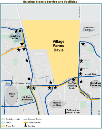
There is no other location in the City that offers this many public transit options and close proximity to so many local destinations. Nugget shopping center is directly across the street. There are 4 k-12 schools within 3/4mile. Downtown and UCD are each about 1.5 miles away.
This central location of the Project with so many public transit and biking options result in less traffic and biking impacts than if 1,800 units were otherwise built anywhere else in the City.
Additionally, extensive bike path and biking safety-related street improvements along with on- and off-site roadway improvements are required by the Project to minimize vehicular traffic and biking impacts.
Bike Path-Related Improvements
• Construction of new Class I shared-use paths along the Pole Line Road (west side) and
East Covell Boulevard (north side) of the site frontages,
• Construction of new Class I shared-use path connections at all intersections into the Project,
• Construction of 2 grade-separated crossings – one under Poleline Rd and one over the
railroad tracks and F. St.
• Develop over 7 miles of multi-use trails, public bike lanes and walking paths throughout
the Project,
• Agricultural Trail Buffer Improvements north and west of North Village.
Additional Biking Safety and Traffic Related Street Improvements
Construction of the following modifications at existing intersections:
• East Covell Boulevard/L Street – New north leg and accompanying signal modifications,
• Pole Line Road/Picasso Avenue – New west leg and traffic signal,
• Pole Line Road/Donner Avenue – New west leg and traffic signal,
• Pole Line Road/Moore Boulevard – New west leg and roundabout,
• Bike crossing improvements on Cannery Loop near the Cannery Dog Park,
• Three high visibility crossings improvements on Covell Blvd between Heritage Oak Park
& Oak Tree Plaza,
• High visibility crossing improvements on Covell Blvd at Birch Lane, and
• Stripe Class III bike route on Birch Lane from Covell Blvd to Pole Line Road.
Additional On and Offsite Roadway Improvements
• Roundabout at Moore Blvd and intersection improvements,
• Traffic Signals at Donner,
• Traffic Signal at Picasso,
• Improvement to the Pole Line/Covell Intersection,
• Frontage Improvements to Pole line Road and Covell Blvd.,
• Signal timing and transit optimization along the Covell Blvd/Mace Blvd corridor to
improve traffic flow,
• Fair share funding toward cumulative traffic impacts including expansion of roadway
facilities and construction of traffic control and safety improvements along the Covell
Corridor.
__________________________________________
E. Alleged High Housing Costs
Myth No. 11 – “The minimum cost of a new home at Village Farms will be $740,000. Only very well-to-do purchasers will be able to afford to live there!”
Fact No. 11 -This is a complete fabrication. Mark Twain once famously said, “There are lies, damned lies, and statistics” when describing how false information is often spread buttressed by the incorrect use of “statistics”.
The original reference to the “minimum” price of a home was incorrectly excerpted by Project opponents from an economic analysis of the property taxes that might be generated by the project. The analysis was done for the City by BAE Associates for the City. That study estimated future property taxes,in part, by assuming the “average” size home on “medium density lots” would be 1,741 sq ft selling for an “average” of $425 /sq ft – or an “average” sales price of $740,000. But that data was based on historical market data on recent home sales prices in Davis, as follows;
“Assessed Valuation
The assumed starting valuation for the residential units is split among medium density,
low density and market rate apartments. The estimated market rate for medium density
units is $425 per square foot (or $740,000), with low density set at $480 per square foot
($1,340,000). Apartments are set at $400,000 per unit. These assumptions are
generated from current market data and staff believes are reasonable.” (see Staff Report 06A-Village-Farms-BAE Fiscal-Impact Memo_4-2-25.pdf)
As project opponents are fully aware, this analysis had nothing to do with what size homes and pricing were actually proposed for the project. In fact, as recently approved by the City Council, there are 1,017 lots in the project that will be less than 5,000 sq ft on which hundreds of townhouses and smaller homes/duplexes will be constructed.
These smaller lots are specifically designed for first-time home buyers. Of these smaller lots, at least 10% will be for attached townhouses expected to be between 800 and 1,000 sq ft. The remaining lots can either be half-plexes or stand-alone single family units and are expected to range from 1,000 – 1,400 sq ft each.
The actual per square foot sales price of these townhouses and smaller half-plex/single family homes will be highly dependent on then current construction costs. But assuming the same $425/sq ft sales price as used in the City’s economic analysis described above, the 800 – 1,000 sq ft townhouses would cost less $425,000 and the 1,000 – 1,400 sq ft half-plex/single family homes would range in price from $425,000 to $637,500.

Leave a comment