

And how the proposed California Forever project threatens livability in Davis and other parts of the Central Valley
By Dr. Glen Holstein
Covering 18,000 square miles, California’s Central Valley is the largest nearly flat valley on earth. It is almost entirely surrounded by mountains and consequently prone to very high temperatures since winds blowing downhill from mountains compress and heat air. That is why Death Valley, completely surrounded by mountains, has average July temperatures higher than those of any month anywhere else on earth. Its mean July temperature is 100.9 degrees F while the mean July temperature of Aswan deep in the Sahara Desert but not surrounded by mountains is 91.8 degrees F. Death Valley even set the all-time scientifically accepted high temperature record of 134 degrees F in 1913.
But the Central Valley is not entirely surrounded by mountains. They open up at the Golden Gate to permit a cooling air flow from the Pacific Ocean called the Delta Breeze to significantly lower summer temperatures in the center of the Central Valley but much less so in its northern part called the Sacramento Valley and its southern part called the San Joaquin Valley.
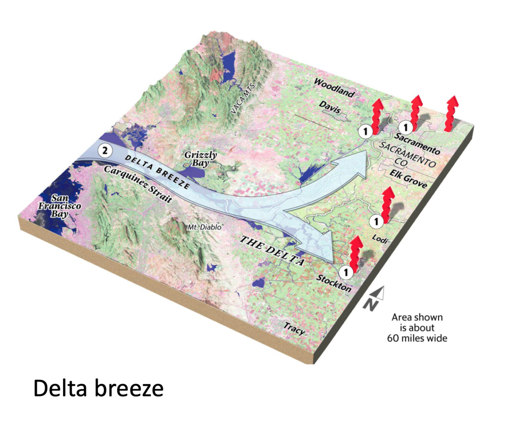
The Delta Breeze’s origin is the cold California Current flowing southward from Alaska. Disturbance where it encounters obstructions like Point Reyes and the Monterey Peninsula causes upwelling from depths that cool coastal water even more.
When warm summer air encounters this cold water its water vapor condenses to create a surface cloud called fog. Chilling moist coastal air this way prevents it from rising and producing rain clouds, which is why California has a mediterranean type climate with dry summers.
Dry air in the Central Valley rises because of heat, however, and its resultant lower surface air pressure attracts the cool fog-laden air chilled by cold ocean water to create the Delta Breeze. Initially its path is wide open through first the Golden Gate and then San Pable and Suisun Bays but a choke point at Collinsville between the Montezuma Hills to the north and the Los Medanos Hills to the south constrains and restricts its flow. That causes its velocity to increase, which is why the Montezuma Hills are one of California’s most significant sites for generating electricity by windmills. The Collinsville choke point also restricts freshwater flow from the Sacramento and San Joaquin rivers into the San Francisco Bay Estuary to form the vast wetland fen complex called the California Delta.
Coastal fog and the Delta Breeze can be traced by their influence on July mean temperatures. In degrees F these are 58.7 at the San Francisco coast and 60.3 inland in the city. At Richmond directly across San Francisco Bay It is only slightly higher at 63.8, but despite its proximity to the Golden Gate, San Rafael is significantly warmer at 68.0 because it is shielded from the Breeze by Mt. Tamalpais.
Further east the Breeze cools Fairfield to 72.3 despite its location inland of its main path across Suisun Bay, and near the Collinsville choke point it cools Antioch to 74.0. Beyond the choke point the Breeze widens as it crosses the Delta but is still sufficient to cool Stockton to 74.2, southern Sacramento to 75.6, and downtown Sacramento to 77.2.

Everywhere else in North America it gets cooler as you go north, but because of its Breeze the Sacramento Valley is the sole exception. 132 miles north of Sacramento Red Bluff in July is 81.8 because of its distance from the Breeze, and Shasta Dam, which is 172 miles north of Sacramento, is 81.4 despite being beyond the north end of the Sacramento Vallet at 1075 feet elevation in the foothills of the Klamath Mountains.
Less surprisingly July temperatures also rise southward in the San Joaquin Valley with greater distance from the Breeze. These are 82.0 at Fresno 169 miles south of Sacramento and 84.4 at Bakersfield 260 miles south.
It is readily apparent that summer comfort and livability in the Central Valley’s center is dependent on the Delta Breeze, but that is currently under threat. A consortium of billionaire Silicon Valley land speculators calling itself California Forever used false claims and threatened legal action to buy up much of the land in eastern Solano County around the Montezuma Hills/Collinsville choke point and have announced various plans for building cities there.
The farming and ranching families tricked into selling land there had for generations productively used it to produce crops while keeping it an oasis for California’s native animals and plants so often pushed aside elsewhere. Rare habitats they protected there included vernal pools and brackish marshes but perhaps even more significant was one of the largest tracts of native prairie left in central California. Often falsely disparaged as non-native annual grassland, this kind of landscape is losing its endemic native birds faster than any other.
But more is involved here than loss of California’s biodiversity and the farming and ranching way of life making it possible. Building cities at its most vulnerable choke point threatens the continued existence of the Delta Breeze that a large part of California including its capitol depends on for livability. The Breeze, like the coastal fog where it originates, is a low elevation phenomenon. When air warms it rises and fog disappears, the familiar phenomenon of fog burn off. Cities exacerbate this because they are always hotter than their surrounding countryside, which is the well-known urban heat island phenomenon. Consequently, building cities, as California Forever proposes, at the Collinsville/Montezuma Hills Delta Breeze choke point will cause it to rise, bun off, and disappear before it ever reaches the Central Valley, This can be seen in San Francisco where within just 6 miles the July mean temperature increases from 58.7 degrees F at its west coast to 60.3 F downtown through urban heat island influence despite the seawater surrounding downtown on three sides. Fortunately, because of the Golden Gate this does not stop the Delta Breeze.

Because the Delta Breeze brings cooling moisture inland it can be confused California’s rainy season since both provide cooling moisture and both enter central California through the Coast Range break at the Golden Gate. The Delta Breeze is a summer phenomenon, however, and the rainy season is in winter. The Breeze moves directly east at low elevations while winter rains move southwest to northeast at significantly higher elevations. This is illustrated by the contrasting climates of Monterey and Santa Cruz, cities just 43 miles apart. Monterey is on a peninsula extending into the cold Pacific fog zone but lacks mountains to its northeast. Consequently, Monterey’s July mean is just 60.2 degrees F and its mean rainfall is 19.2 inches, while Santa Cruz, somewhat separated from the fog belt by Monterey Bay, has a 63.4 degrees F July mean but mean rainfall of 28.97 inches because the Santa Cruz Mountains rise behind it to its northeast.
California’s fog belt is where places have July temperatures of 60 degrees or less and distinctive forests dominated by Bishop and Monterey pines, Sitka spruce, and California wax myrtle are present where it is relatively undisturbed. In southern California the fog belt is distant from the mainland in the Channel Islands, but touches it again further south at Ensenada, Mexico, where its characteristic fog pines are once again present. Contrary to a widespread myth, redwoods mostly avoid the fog belt and depend on winter rains that exceed 40 inches as in the mountains above Santa Cruz.
SOURCES: Climate data is from Weather America: the latest detailed climatological data for over 4,000 places edited by Alfred Garwood and published by Toucan Valley Publications. An exception is for that of Aswan, Egypt, which is from World Climatic Data by Frederick Wernstedt and published by Climatic Data Press. Plant distributions are available online from Calflora and information about widely known phenomena including the Delta Breeze, urban heat islands, and world high temperature records set at Death Valley is widely available online from numerous sources. A good source for the geography discussed here including the Collinsville choke point is California Road and Recreation Atlas published by Benchmark Maps. The importance of correctly naming California prairie is discussed in my article Prairies and Grasslands: what’s in a name published in Fremontia May-Sept 2011 volume 39(2-3). Information about California Forever is available from the many activists of Solano Together resisting its invasion of their homeland.



Leave a Reply