
By Rena Nayyar
This is a response to a recent article by one of the Village Farms partners regarding the project’s proposed flood control. The article makes the claim that Village Farms will be “better protected from flooding than most of Davis.” That claim is just marketing. The Village Farms EIR does not support this claim. Links to city documents are at https://www.cityofdavis.org/city-hall/community-development/development-projects/village-farms-davis
The article didn’t cite any sources showing a track record for their “sound, proven engineering design principles” that would be employed to reduce flood risk. The “hundreds of pages of engineering analysis related to the impact of extreme storm events to the project…demonstrate that Village Farms Davis will be better protected against flooding” is exaggerated as these involve modeling based on assumptions and not actual plans for how this will be implemented. In fact, the flood and stormwater strategy is still being assembled piecemeal, after the circulation of the Draft EIR. It is meaningless for them to praise the merits of a plan in flux. Village Farms is not a simple “raise the pads” project. It relies on a complex coordinated stormwater and grading strategy across a huge site in a flat floodplain basin with known downstream flooding problems. In that kind of environment, there are lots of failure scenarios. This problem requires completed project level planning that has not yet been done.
In the Final EIR response to comments on page 2-10, liners are being proposed for Channel A to try to prevent the contaminated groundwater including PFAS “forever chemicals” from mixing with the Channel A runoff water. When the City starts talking about Channel A “liners” and isolation measures to prevent stormwater from interacting with groundwater– those are major changes. This is a sign that the system is being engineered around problems that were not resolved when the public reviewed the Draft EIR.
Since the flood plan is so incomplete and not yet approved, the project’s flood story may require future changes, for example in maps (Final EIR page 3-12). On page 4-83 the Final EIR says that because the drainage patterns of the area will change, “a design-level drainage report shall be submitted to the City …for review and approval” when the first tentative subdivision map is submitted. Similarly, the response to Comment 217-54, page 2-996 says
“the preparation of a final Stormwater Control Plan, …cannot be prepared at this time ” and “the appropriate time for a Stormwater Control Plan will be when a tentative subdivision map has been prepared”.
So, the City is being asked to certify the Final EIR now and our community is being asked to wait until the developers are ready to start building to find out what the plan actually is, when it will be too late. Because the Final EIR introduces multiple late-stage engineering measures, it violates the CEQA’s requirement for a stable project that the agencies and public have a fair chance to review and comment on. This also makes the City’s process legally and ethically vulnerable. CEQA recirculation is about significant new information after the DEIR. (new project features, new mitigation, and new technical premises) that the public did not get an opportunity to comment on. Village Farms has multiple independent EIR recirculation triggers, including adding liners to Channel A and because the project’s flood and stormwater plan is a moving target.
Floodplain compliance is not just an engineering issue. It is also a process issue involving FEMA and other regulators. FEMA has experienced major recent political funding cuts affecting multiple FEMA programs which now have questionable ability to provide adequate certification or flood mitigation.
We have an example in Davis history to show one reason why this conversation is so important. The re-engineering of the flood plain for the Mace Ranch development in the 1980’s-1990’s failed, resulting in flooding at Howat Ranch to the northeast. The City of Davis was sued and ultimately settled by purchasing the 760-acre property. Because the city approved it, the city was liable. So, we had to pay for the developer’s failure. Wildhorse is immediately downstream of Village Farms. If Wildhorse is impacted like Howat Ranch, the City will not be able to purchase the property (as in the Howat Ranch situation) to remedy the flood control failure.
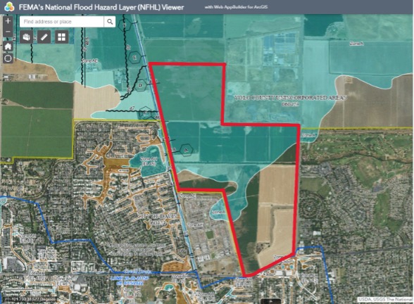
After attending many City Council and Commission meetings on Village Farms, reading much of the EIR’s, talking to people with years of experience on this issue, and looking at the flood maps and information at FEMA.org, it is clear the proposed Village Farms development proposal does have a major flood risk without a comprehensive flood plan.
The article didn’t mention the one million cubic yards of soil they would need to move to try to fill in the enormous flood plain they wantto build houses on. This would take at least 100,000 ten-cubic yard truck loads creating dust containing high levels of arsenic. Also, hundreds of trees providing Swainson’s Hawk habitat would be torn out to re-route the channel. The trees lining the sides of the channel currently play a role in helping with flood control to some extent.
The comparison claims of the Bretton Woods and Village Farms flood plains are not valid because the Village Farms flood plain is more than 4 times larger than that of Bretton Woods.
In Planning Commissioner Greg Rowe’s article explaining his concerns about Village Farms and his vote, he was correct in describing the Village Farms flood control “plan” as an “unproven stormwater contrivance”. He summarized what the EIR information shows, and what information it lacks. The Village Farms project is asking Davis to certify confidence in a flood protection system that has not been fully specified nor fully validated.
In conclusion, the approval process for this projectisbeing rushed and corners beingcut to make the June 2026 ballot deadline, regardless of the consequences. I urge the City Council to not certify the inadequate Village Farms EIR, and I urge the community to oppose the Village Farms project. Village Farms, as proposed, would bring serious impacts, costs, and long-term liability to the City.
Rena Nayyar is long-time Davis resident who follows local Davis land use issues.

Leave a comment