
The City Council will soon be making a decision with serious consequences of whether to certify the Village Farms EIR. It is critical that they deny certification. This EIR is seriously inadequate and flawed, and certifying it would expose the City to liability while surrendering the City’s leverage to correct course on this disastrous project.
Background
A similar version of Village Farms, Covell Village, was rejected by Davis voters 60:40 in 2005 for many of the same reasons this project and its EIR must be rejected now. The developer, John Whitcombe (Tandem Properties partner) bought the 386-acre parcel in bankruptcy due to the many obstacles making it impractical to develop (originally costing $11 million) for a mere $3.2 million. The site has long been handicapped by an enormous floodplain, unmitigable traffic, access issues, extraordinary infrastructure costs, and toxics from the adjacent unlined Old City Landfill and Sewage Treatment Plant.
Aberrant, Chaotic, Rushed Process
The Village Farms “process” has been aberrant. The developer demanded that the City push his project ahead of other projects being processed. The City caved and has been accommodating him ever since, to the detriment of the community. The apparent objective has been to rush this “legacy” project onto the ballot, but the EIR and key documents still contain a plethora of “to be determined,” and “if feasible” language.
Public meetings were rushed through the holidays, when many residents were unavailable to comment. In backwards order, the City Council held a workshop the day before the Planning Commission was asked to recommend certification of a Final EIR that did not yet exist. Never in Davis’s history has the Planning Commission been asked to recommend certification of an EIR before it was complete, yet staff pressured for that recommendation anyway. That’s not transparency, it’s corner‑cutting. The City has prioritized a June 2026 ballot timeline over the community’s right to a fair, thorough CEQA process.
Village Farms: Serious Impacts, Costs, and EIR Inadequacies
Massive traffic
Village Farms would add at least 15,415 car trips PER DAY, from 1,800 housing units on the 498‑acre site, the largest residential project ever proposed in Davis. This is likely an underestimation because it assumes substantial public transit use. Covell Boulevard and Pole Line Road, already heavily impacted, would be gridlock, degrading streets to Level of Service “F”. Cut-through traffic would impact many neighborhoods of cars trying to avoid this congestion.
200‑acre FEMA floodplain
Village Farms has an enormous 200-acre FEMA Hazard Zone A floodplain, predominantly north of Channel A. The flood extends massively to the north (see FEMA flood plain graphic). A fundamental planning principle is to never build on a floodplain this large. State legislation discourages such approvals because it cannot be expected to bail out cities that build in major flood hazard areas especially with climate change and more atmospheric rivers. Surrounding neighborhoods including Wildhorse would be susceptible to massive flooding. The flood control is still in the planning process, yet the developers are claiming that it will be “ok” and that should be enough to certify the Final EIR.
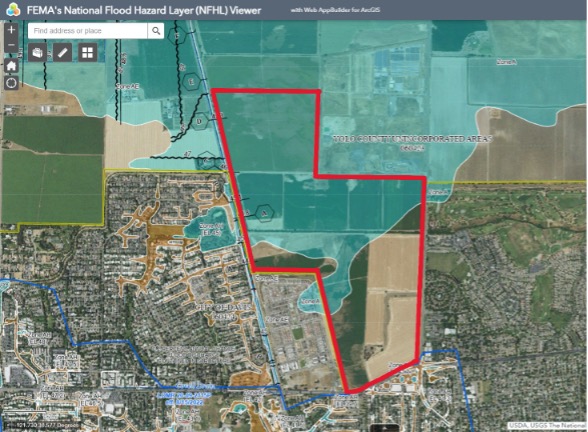
Furthermore, FEMA’s current moratorium affects the project’s assumed floodplain relief pathway. Village Farms and the City are making an unwarranted assumption that FEMA will provide timely relief to support the project’s expectations. Buyers, lenders, and insurers will not accept wishful thinking, and neither should the City Council. The Village Farms Draft EIR conveniently did not include some key General Plan policies regarding flood plains — a relevant EIR inadequacy.
It is important to note that a failure to engineer a large flood plain in Davis occurred in the 1990’s. The reason the City owns Howat Ranch is because the Mace Ranch engineer’s flood plain control plan failed. As a result, the Howat Ranch located to the north-east flooded, and they sued the City. The City settled by purchasing the 760-acre Howat Ranch. In the case of Village Farms, it would be neighborhoods like Wildhorse that would flood, and there is no way the City could buy their way out of a disaster like this. Yet, the Village Farms flood control plans are not completed and are being deferred until after the developer gets entitlements, like a certified EIR which is clearly inadequate.
Toxics from adjacent unlined Old City Landfill, methane, and burn‑pit contamination
Village Farms borders directly adjacent to the unlined Old City Landfill and Sewage Treatment Plant, which has never been cleaned up. Groundwater monitoring has revealed high levels of carcinogenic PFAS “forever chemicals” and manganese migrating to Village Farms. For 30 years, this dump also operated as a massive burn pit for unregulated waste, raising the likelihood of carcinogenic residues (dioxins, furans, and polycyclic aromatic hydrocarbons (PAH’s).
Yet, the DEIR did not include: testing for burn‑pit residue toxics typically resulting; the need for a 1,000-foot exclusionary buffer; nor methane testing and protections needed near old landfills. If the City certifies first and asks questions later, it leaves the City wide open when agency enforcement and lawsuits inevitably follow.
Soil‑toxics
The project’s own testing reports ultra‑high toxaphene and elevated lead levels at the proposed Heritage Oak Park where children would play. There is still no clear, Department of Toxics Substances Control (DTSC) led cleanup pathway with binding standards, sequencing, and oversight sufficient to support certification. If the City is going to put a park near known contamination, the regulatory coordination and enforceable remediation plan must come first.
Channel A reroute, habitat destruction, and the “dig‑pit as agriculture” fiction
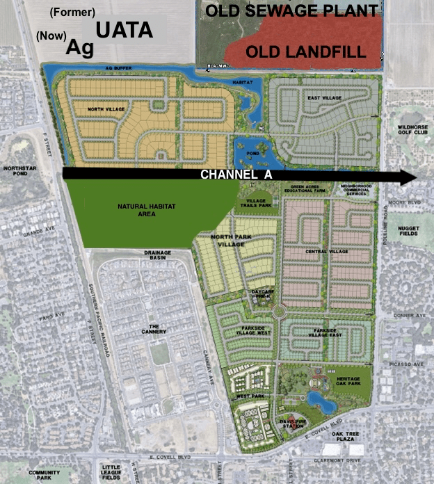
The planned rerouting of Channel A is being sold as “flood control”, but appears insufficient to replace what nearly 500 acres of agricultural land currently absorbs. It would remove hundreds of trees, devastate channel habitat, and require massive earthmoving, including ONE MILLION cubic yards of soil from the former Urban Agriculture Transition Area (UATA) site.
The project now claims this 107‑acre,10‑foot‑deep dig‑pit crater will, instead, be designated “agriculture,” which is absurd. This dig-pit and secondary detention basin, are urban uses, not agricultural uses. This convenient relabeling then deprives the City of the required 2:1 agricultural mitigation for an urban use. The designation must be corrected back to UATA, and the City’s own 2:1 mitigation requirement must be enforced—no more giveaways to the developer.
This “plan” looks seriously inadequate to control the massive flooding as commented in the DEIR by UCD Geosciences professor and flood control expert Dr. Nicholas Pinter. There is also an obvious water‑pollution risk where the contaminated groundwater can mix with Channel A from below, and storm events can carry contaminated water and sediments from the dig‑pit basin to Channel A from above. That runoff moves east through Wildhorse, then through wetlands to the Vic Fazio Wildlife Area and through downstream waterways, to Yolo Basin and eventually the Sacramento River. These are foreseeable pathways that demand serious analysis and enforceable protections before certification. This DEIR concern was raised by hydrologist Dr. Steve Deverel, who has overseen the Frontier Fertilizer Superfund site clean-up in Mace Ranch for over 25 years.
Unprotected vernal pools
The vernal pools remain at risk from massive grading and fill, soil movement, yet currently there is still no conservation easement or management funding in place. The EIR downplays this rare habitat and its protected species, including the endangered Vernal Pool Tadpole Shrimp.
Unsafe access issues and infrastructure cost impacts
The Pole Line Road. and F St. bicycle/pedestrian grade‑separated crossings are still described with “if feasible” language, and even the revised optimism offers no certainty. So far, the City is requiring the developer to only pay 20% of these multi‑million‑dollar projects, imposing costs to the community. The same developer has failed to deliver the Nishi grade-separated crossing or the housing. What makes us think he would deliver TWO grade-separated crossings at Village Farms? If the City wants these improvements, it must require 100% developer funding and enforceable deadlines.
Unaffordable housing that will not bring hundreds of kids
Village Farms plans at least 80% market‑rate housing where the cheapest home would be $740,000. This means a house payment monthly of $6,000 to cover mortgage, taxes, insurance, CFDs, and fees. The project is being marketed as a remedy for school enrollment decline. But local workers and families with young kids cannot afford these houses. The project will not bring hundreds of kids as the school district would like to believe. Further, the floodplain compliance uncertainty undermines any near‑term housing timeline as well. Further, the Village Farms buildout would last at least 15 years of construction traffic mayhem. This includes moving one million cubic yards of soil to try to raise the massive flood plain, and re-routing Channel A, the main drainage system of the City.
Affordable housing is being shortchanged. Now, just days before the Council is deciding whether to entitle this project, there isn’t even a final affordable housing agreement. Instead, there is a “tentative agreement” with convoluted caveats and pitfalls. The developer is trying to secure entitlements before all of these details are fully thought through by the City. Also, the developer is only dedicating 16 acres of 18.6 acres required (another giveaway), and not defining its location or configuration.
The EIR must not be certified
The Village Farms proposal is too big, has too many impacts and costs, and the vast majority of the housing is unaffordable to most local workers and young families.
Furthermore, Village Farms has been fast‑tracked through a process that has prioritized the developer’s wishes over the community’s need for a fair process and a legally adequate EIR. Davis has a certified Housing Element until 2030. There is no emergency justifying impacts of flooding potential, toxics exposure, destroying habitat, fiscal risks, infrastructure costs, massive traffic, or basic CEQA compliance.
Most glaring is the failure to analyze a reduced‑footprint alternative like the environmentally superior alternative included in the prior Covell Village EIR. Yolo County planning staff and Davis residents formally asked the City for a reduced‑footprint alternative for developing only below Channel A, but were ignored. The vernal pools would be protected and the housing reduced to 900-1,000 units. That alternative must be analyzed because it distances housing from the floodplain and the toxics, and it would reduce major impacts, including traffic.
Certifying this EIR would relinquish the City’s ability to correct course and expose Davis to years of risk and litigation. The City Council must not certify this inadequate and incomplete Village Farms EIR for this disastrous project.
Residents concerned about Village Farms can contact Citizens for Responsible Planning at citizens@dcn.org or (530) 756‑5165.
Eileen Samitz is a former Davis Planning Commissioner and served on the City of Davis 2001 General Plan Update Land Use Committee and the subsequent Housing Element Update Committee.

Leave a comment