
By The Davis Citizens Planning Group
The Davis Citizens planning group would like to present our vision for a pragmatic, realistic, and sustainable way to develop our city going forward. This vision represents several months of work and builds upon a series of articles we have published over the past two years on the topics of how we might plan our city to have housing that is more affordable, sustainable, and a city that is more liveable and economically viable.
In the past we have framed our commentary in a reactive way with respect to the developments in the housing proposals being considered. Going forward, we have decided to be more proactive, starting with best practices, and advocating for a top-down city-wide vision for how we develop our city not just for the upcoming 25-year general plan cycle, but looking towards the end of the century.
Over the past few decades, more and more thinkers in the field of urban planning have come around to endorsing what is essentially the same set of strategies for urban planning:
Best Practices in Planning
- Start with transit, connecting:
- Centers of Employment
- Commercial districts for shopping
- Corridors of housing that are either already dense, or can be densified
- Intentionally create mixed-use walkable public spaces (that aren’t dominated by cars)
Note that you can’t have #2 without #1.
So many urban planners agree on this general framework that it has come to be called by a variety of different names: “15 Minute cities” / “Strong Towns” / “Walkable Cities” Even the LEED-ND “Rubric” that the council put forth a couple of years ago for analysis purposes is based on these same common principles, and they all implicitly arrive at one conclusion: Building our cities on the assumption that ‘everyone will drive a car everywhere’ was a HUGE mistake.
Today we are unveiling a model of what it might look like for Davis if we intentionally followed these principles and applied them to our town.
Planning Starts with Transit
Good cities are not planned parcel by parcel. They are designed as systems, and the most critical system in a city is its “circulation”: How people navigate between jobs, shopping and their homes.
The most important of these is the relationship between transit and land use:
- Density without transit increases congestion and reduces livability
- Transit without density lacks the ridership to be viable
Planned correctly, these two elements reinforce each other. Planned separately, they fail. So Density and transit MUST be planned together.
And just as important: that density should be focused within a short walking distance—roughly a quarter mile—of those transit lines.
There are many success stories of formerly auto-centric cities embracing transit as a alternative to building their cities around cars, and the results are clear: if you build “good” transit, people will take transit.
A “good” transit system is characterized by a few traits:
- Frequent: It runs frequently at least every 15 minutes.
- Convenient: It takes people close to where they want to go
- Connected: When transfers are needed, they are brief and convenient
Nobody makes a good transit system by running a bus through low density sprawl once an hour.
Unfortunately this is why very few Davisites make use of our existing transit. Unitrans takes people TO campus and stops there, And yolobus connects cities in a general / regional way, running only every half hour to 45 minutes. Neither of these services are designed to serve everyday intra-city uses for working Davisities. We are already talking about a very different kind of service than we currently see from either YoloBus or Unitrans.
Regarding “Density”
To be clear, when we say “density” we only mean “more than 15 housing units per acre” which is the lower threshold at which high frequency transit service becomes sustainable. We are NOT talking about high density housing anywhere in this proposal.
For context:
- townhomes tend to be ~17 units per acre,
- 4-plexes closer to 22.
- Small apartment buildings are 25-35 units per acre.
- We already have student housing along russell boulevard that is at 80
- Several of the downtown proposals are above 80.
As you will see in our projections below, our default assumptions we use never go beyond calling for more than 30 units per acre. The equivalent of 2-3 story apartments in our densest neighborhood hubs.
So when we say “densify” we are only talking about creating moderate density housing in an intentional way and in the areas where it can be served by transit: which is only ¼ Mile around the transit station. They key is to do it deliberately and thoughtfully.
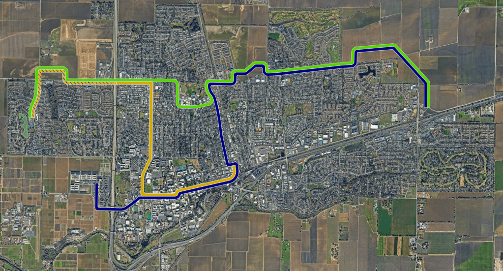
The Layout.
Our proposal establishes 3 transit lines designed for high-frequency service:
- The Blue Line traverses campus, goes through downtown, touches the Amtrak station, continues up F street and all the way around the mace curve
- The Gold Line starts at Amtrak downtown, goes across campus then up Anderson boulevard before heading west to the Davis marketplace. The gold line we propose thinking about in two phases, with the second phase later extending further past the marketplace out to lake boulevard.
- The Green Line connects the Blue and the Gold via the high school for residents to want to get across town and don’t need to detour downtown or to campus.
These alignments connect the places where people work ( campus and downtown) to major shopping centers and to areas where there is either already denser housing, or where denser housing can reasonably be constructed.
The Densification Strategies
Along these lines we have several opportunities for establishing more housing
- Densification of existing arterial neighborhoods. When existing neighborhoods turn 80 years old, structures start getting replaced by their owners. At that age, we can re-zone to allow property owners to replace single family homes with multifamily if they choose.
This image shows the corridor properties in brown along with the decade in which those neighborhoods turn 80 years old.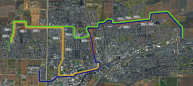
- Re-Zoning urban strip malls to mixed use. This is what many people were calling for at the university mall site – a conversion of an auto-centric strip mall into a mixed use site with residential over commercial, like we already see downtown.
This rebirth of auto-centric strip malls into pedestrian friendly “neighborhood centers” is the specialty of the neourbanist movement, and there are hundreds of examples where lovely public spaces have been constructed in places which previously were dominated by parking lots.
We see this eventually happening at all of the major shopping centers around town along these lines including Oak Tree Plaza, and perhaps at the entire strip of Covell From Anderson Plaza to the Davis Marketplace.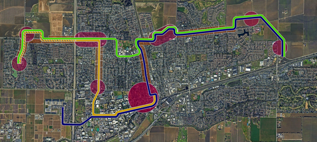
- Development of NEW medium density housing and urban centers. For properties along the lines that are not yet developed, we have an opportunity to do some intentional place-making: Create walkable neighborhood centers described above, dotted around the city serving their local residents. The largest opportunity to do this is on the blue line around the mace curve and indeed, the mace curve is at risk of being a “food desert” if we do NOT specify that there be a neighborhood center there.
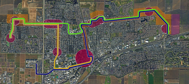
- Development of more single-family homes on greenfield sites outside the range of the transit lines.
(Note that we are including this last strategy for fair comparison purposes only. We do not generally support the creation of single family housing unless it is for use as a lever to compel developers to build out means-tested affordable housing. For an explanation why, look up “strong towns” or watch this playlist – it’s very much worth your time.)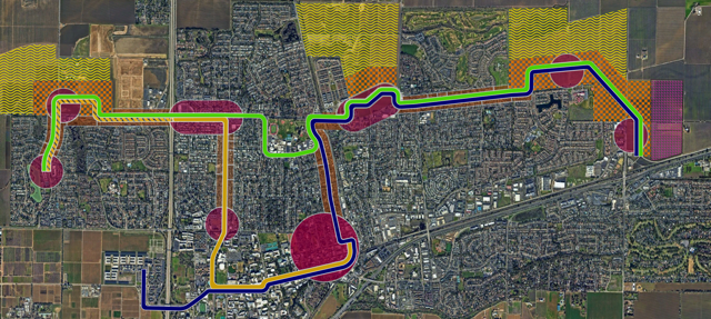
Development over time
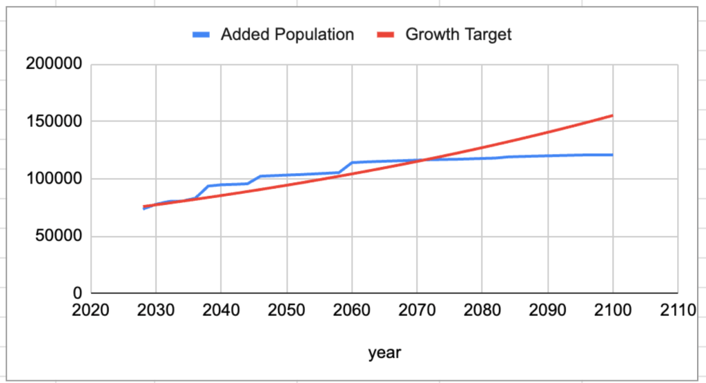
Having laid out these transit lines and identified the properties that could be up-zoned or developed along their service routes, we created a spreadsheet that allows us to see just what the impact on our city might be if we embraced these options, and critically, how our city might change over the course of time.
This allows us to see how much population we are adding to our city over the coming decades.
Here is an example output of this model assuming that we are trying to hit a 1% growth target and we apply our densification + transit oriented strategies only… and only moderate density assumptions. As you can see, this is enough housing to last us to 2070 under these assumptions.
Some details about the model
For our our arterial neighborhoods such as Anderson, we only expect that densification will start when the neighborhoods hit 80 years old, and even then, maybe only half of the properties will densify, and the conversion will likely take 20 years. So we would not suggest a scenario that calls for bulldozing those areas and forcing a conversion artificially.
Similarly, we are not going to redevelop every shopping center and every property around the mace curve at once.
We are looking for a long-term supply of housing, and one of the principal aims of this analysis is to investigate just how much of a housing supply we might produce via these strategies.
To that extent, the final part of our model is a city growth target, which can be set at the rate you desire, along with an amount of short-term growth to help our schools and working class… and then you can see just how much time we buy, how much growth can be accomplished through these strategies along these lines.
Our spreadsheet can be found HERE, and we encourage readers to play with it. Simply save your own copy of it, and feel free to edit.
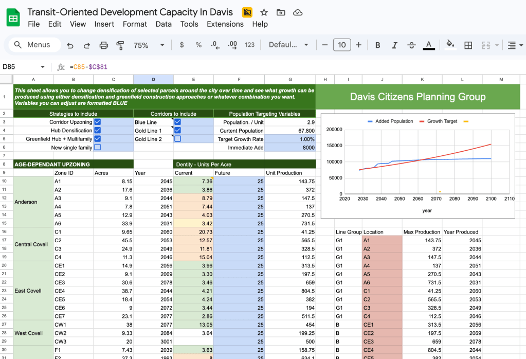
There are check-boxes that allow you to turn on and off the individual transit lines ( and the properties along them) and to turn on and off different development strategies. You will see that we have recorded the acreages of the parcels along these routes and estimated the existing densities we find there. If you want to go deeper, you can play with the densification specification and the build-out date for any of the properties to see how much housing we can produce and WHEN, and then compare that to the growth rate for the city that you think is appropriate.
Analysis of our options.
Of course, we hope you will play with the spreadsheet and come to your own conclusions, but we have spent a few weeks with this model, have tested a variety of assumptions and have some high-level observations we think are generally fair:
- Densification of existing neighborhoods alone doesn’t move the needle. For years, opponents of development proposals have suggested that we should “densify instead” of building anything new – but this analysis shows that if you include both of the densification strategies and compare them to a modest 1% annual growth rate, they don’t get us where we need to be..
Yes, we technically could densify other parts of our city not considered here, but density and transit need to go together. Density without transit means a lot more cars. So for the purpose of sticking to best practices and aspiring to be a sustainable city, strategies 1&2 simply aren’t enough. - Embracing “Transit Oriented Development” gets us enough housing through to 2070. That not just through the end of the upcoming general plan, but the one AFTER that as well.
Again this is assuming a 1% growth rate, and the eventual development of the multifamily properties + new neighborhood centers around the mace curve and out towards Lake boulevard… But that gets us all of the housing we need until 2075. Most people reading these words today will no longer be alive then. - “Sprawl” is entirely optional! With a focus on two transit corridors and simply building moderate density housing along them, we can provide affordable, energy efficient housing that doesn’t snarl our city with automotive traffic, consumes the minimum amount of farmland AND supports our local economy.
Lots of Davis residents we have talked to say that they are not against “growth”, they are against uncontrolled “sprawl”. For the first time, we now have an option on the table that gets us a lifetime worth of growth – and without the sprawl. It is our hope that this concept laid out with this much specific detail will get people thinking about growth differently and provide us an option for growth that is more generally acceptable to al
Whats’ next?
We want to hear from you. Do you like this vision? What concerns you?
We think that a lot of the housing debate in our city is driven by fear of the unknown. Measure J gives us a veto against bad projects, and we like being able to have that control, but Measure J/R/D does not give us a pathway to assert OUR will as to what we want our city to look like.
We can defeat this fear of the unknown through PLANNING, by declaring positively what we want to see.
If we as a community can move away from simply debating the most recent developer proposal, and instead have a detailed proactive discussion about what kind of growth WE want, and what WE might be willing to accept, that common ground might be found.
Yes, there are those who will not accept growth under any circumstance, but most Davisites are united by a desire to have a nice, liveable, environmentally sustainable, low-traffic city that is financially healthy. If THAT is what we want, then there is really only one way to get it. That might be something we find we can agree on.
The Davis Citizens Planning Group
Alex Achimore – Architect & Urban Planner
David Thompson – Affordable Housing Developer & Urban Planner
Anthony Palmere – Transit Planner, Former head of Unitrans
Richard McCann – Environmental Policy Consultant
Tim Keller – Economic Development

Leave a comment