[This Op-ed article was originally published in the Davis Enterprise on March 22nd in response to February 18th Davisite and Davis Vanguard articles in which Alan Pryor asserted that valid concerns related to contaminants associated with the proposed Village Farms Davis project, are “myths”. This is a slightly modified version of that article.]
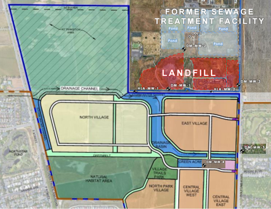
This map from the Draft Environmental Impact Report, which was not included in the Davis Enterprise Op-ed article, shows Village Farms proposed drainage and housing adjacent the Old Davis Landfill/Burn Dump and Sewage Treatment Plant and monitoring well locations. The liner discussed in the Davis Enterprise op-ed article and the Partial Draft Response to EIR Comments does not appear in the Development Agreement or Baseline Project Features.
By Steven Deverel, Marjorie Longo, and Robert Okamoto
There was a recent attempt to dismiss contaminant risks related to the proposed Village Farms project in north Davis. We herein summarize data and potential risks related to contamination from the adjacent Old Davis Landfill, Burn Area, and Wastewater Treatment Plant.
First, it was posited that contamination from the landfill has dissipated, per and poly fluoralkaline substances (PFAS) are not a health issue and that Village Farms Davis will not be built on the landfill.
I learned something very interesting in the last few days that gave me an incredible sense of “Here we go again!” Specifically, where is the $6 million Affordable Housing contribution coming from?
Alan Pryor has said on the Vanguard that the $6 million is coming from the developer, but is it? Or is it actually going to be coming from the taxpayers?
The history of the Cannery tells us that there is a very good chance that the taxpayers will end up footing the bill for the $6 million. But because Village Farms is so sketchily defined/described, there is no way to know.
Cannery was much better and more completely described/defined, but one year after the documents had all been signed, they came back to the City saying they “needed” $12 million more cash. City Council negotiated the $12 million down to $8 million … and then imposed a 30-year Mello-Roos Tax on the Cannery residents, with the taxpayer total payments of which amounting to more than $21 million taken out of those taxpayers’ pockets.
There is nothing in the Baseline Features or the Development Agreement for Village Farms that tells Davis voters whether there will be a Mello-Roos levy (often called a CFD), and/or how large the Mello-Roos levy will be.
To add insult to injury at The Cannery, the City Council never asked the developer what value the City would be getting back in exchange for the $12 million being asked for, or the $8 million eventually given. Unfortunately, the City got zero dollars of value in that Cannery situation.
We have no way of knowing what might happen in the case over Village Farms. This is just one more way this project is not ready for prime time, and the only logical vote on Measure V is “No.”
Greenwald concedes Village Farms could result in little or no affordable housing being built
By Roberta Millstein
I want to let readers know about some followups to my two previous posts about the toothless promises concerning Affordable Housing and affordable-by-design housing in Village Farms, which we will vote on in June as Measure V. One is that I meshed the two articles into one, did some more editing, and submitted the new article to the Davis Enterprise, where it appears, here. Now the analysis of affordable housing in Village Farms, which rests in large part on understanding the difference between Baseline Features and Development Agreements — and which “promises” appear where — is all in one place.
The second thing I want to highlight is a response of sorts to my DE article from the Davis Vanguard, here. What I find interesting about this response is that at each point David Greenwald actually agrees with what I say about the promises of affordable housing. Indeed, there really is no other interpretation — it’s in black and white that the affordable housing is so flexible that the project could end up with little or no affordable housing at all. And he agrees that our city councils have a history of giving in to developers. Quoting from Greenwald’s article (my emphasis added):
There is no perfect project and there is no perfect time. But, there are good projects that come at the right time. Such a project is Village Farms. There are a few reasons I will vote YES for Village Farms.
First, Village Farms is contiguous with the City and I would label this site infill. It is surrounded by The Cannery, F Street, Covell Blvd and Poleline Road. While this land is farmland and has been planted under tomatoes, wheat, corn over the years. It is surrounded by our community on three sides and is ideal for development.
Second, the property that Village Farms sits on is in the sphere of influence created in 2008. What is the Sphere of Influence? “The legislature created the mechanism a “’sphere of influence’ (SOI) as a means for planning of probable physical boundaries and service areas within a local agency…SOIs are designed to both proactively guide and respond to the need for the extension of infrastructure and delivery of municipal services to areas of emerging growth and development.” Village Farms (formerly Covell Village) is largely within the City’s SOI. This means we as a community, former Councils as well as City Staff, have thought for decades about the areas of future growth and this is one of them.
In a previous article, I explained how it is only the Baseline Features of a project that are guaranteed to be built. I further explained that the Affordable Housing that Village Farms claims to provide is not part of the Baseline Features, i.e., the features that we will vote on as part of Measure V — it seems to be, but then by referring to the Development Agreement where it says only that the City “may elect to request Developer to construct the units” (emphasis added), it becomes clear that there is no guarantee of Affordable Housing at all. (Please refer back to that article for details).
In this article, I will explain that the “commitments” to affordable-by-design housing that proponents tout in their ballot arguments and elsewhere are similarly ephemeral. Voters should be aware that the project may not include much affordable-by-design housing at all.
First, let’s clarify. In California, capital ‘A’ Affordable Housing has a specific legal definition, with classifications based on income as a percentage of Area Median Income (AMI). In order to qualify to occupy an Affordable Housing unit, one has to fall into the requisite income class.
But “lower case ‘a’”, affordable-by-design (also called “missing middle”) housing has no such income restrictions. Anyone can purchase it, regardless of income. However, as the name suggests, the point is that certain types of housing are likely to be less expensive, and thus more affordable: duplexes, triplexes, cottage courts, and multiplexes are examples. They are still “market rate” — they will cost whatever the market will bear — but the hope is that they will be affordable to those who do not qualify for Affordable Housing but who do not earn enough money to purchase larger, single-family homes.
I have been a fairly consistent opponent of most peripheral development projects in Davis over the past decade. For instance, I was the Principal Officer, Treasurer, and Chair or Co-Chair of the No on Nishi 1 (Student Housing), No on West Davis Active Adult Community (Senior Housing), and both the No on both DISC 1 and DISC 2 campaigns (primarily Commercial).
All of those peripheral annexation measures failed except West Davis Active Adult Community. But none of these projects provided for family housing for modest income buyers. I think Davis desperately needs that type of family housing and I believe the Village Farms Davis project provides it so I support the Project.
As a result, I recently both publicly endorsed the Yes on Measure V campaign and was a co-signer of the Rebuttal to the Argument Against Measure V that will appear on the June ballot.
Many folks that I had previously worked with opposing other projects have accused me of abandoning my slow-growth and/or environmental principles after hearing of my endorsement of Village Farms Davis or reading some of the articles I have published about various environmental aspects of the project. Some are saying it is inexplicable to them why I would make this seemingly sudden change in my views toward peripheral development and endorse this Project.
Well, the reasons are actually pretty simple. I opposed past peripheral development projects because I did not feel any met all of the 3 primary criteria that I look at when considering supporting or opposing a project. And the reason I can now support Village Farms Davis is because I can now check-off each of the boxes for the same 3 criteria – 1) the Features of the Project itself, 2) the Location of the Project, and 3) the Quality of the Developers of the Project.
Roberta, thanks for recently highlighting this huge legal loophole in the official language citizens will be voting on in Village Farms June ballot.
“City “may” elect to request Developer (Village Farms) to construct the units”
I asked Google AI for a description of the word “may”
Google AI Overview “May” is a versatile modal verb used to express possibility/uncertainty (“It may rain”), grant or request permission (“May I leave?”), or express a polite wish (“May you be happy”). It signifies a ~50% chance of occurrence and acts as a more formal, slightly less certain alternative to “might” or “can”. Merriam-Webster
It would appear that every lawyer can explain and defend the meaning of the word ‘may”. So clearly this housing may or may not be built. “May” has a very different meaning than “will” or “shall”.
So rather than me saying , “I “may” not vote for the VF project, with “may” remaining in the language the citizens will be voting on I will “not” be voting for VF. The city council should not have approved “may” in the wording.
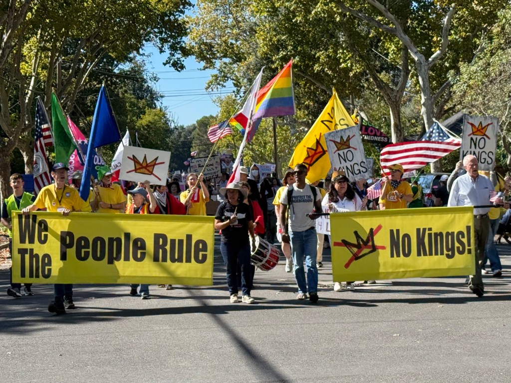
Thousands of Yolo County residents gathered in Davis in October for the second No Kings march and rally. Indivisible Yolo is organizing the next No Kings event for March 28 in West Sacramento. Photo by Laurie Friedman
Countywide event will be held alongside protests across the country
(From press release) Following in the footsteps of farm workers in their historic march across the Tower Bridge with the farm workers movement 60 years ago, Indivisible Yolo is joining with the Sacramento Labor Council for Latin American Advancement AFL-CIO and Change to Win, along with Davis Phoenix Coalition, to host the third No Kings Yolo on March 28. The event will begin with a democracy fair at River Walk Park in West Sacramento at 10:30am with activities for all ages and a brief speaker program. Supporters will then march at noon across the Tower Bridge to the state capitol to join Indivisible Sacramento’s No Kings rally. Learn more and sign up: https://www.indivisibleyolo.org/no-kings-yolo.
No Kings Yolo, this time themed “We are the Power! Somos el Poder!,” is part of the largest single-day national mobilization in history expected to attract millions nationwide as people gather to protest Trump administration policies – including ICE terrorization, unauthorized wars and threats to working families in the community – and to remind the president that America is a democracy.
With the for and against ballot arguments for Village Farms and their rebuttals posted to the County’s website (as Measure V), and the campaigns starting to ramp up, I thought it was important to highlight what are technically known as the projects Baseline Features. These are available as part of the “Full Text of Measure V” on the County’s website, and I encourage Davisites to take a close look at them, but I wanted to point out a couple of things first.
Most important to note is what it means to be a Baseline Feature. As the text of the Measure itself clarifies:
Beyond the Baseline Project Features there are other additional requirements for the Project, including but not limited to, the mitigation measures set forth in the Village Farms EIR, and the Development Agreement that, while important to the Project, are not Baseline Project Features and may be modified with the approval of the City after the appropriate public process (emphasis added).
Another way of saying this is to point out that only the Baseline Features are guaranteed parts of the project. Anything else can be changed with a vote of the City Council — and here one should keep in mind that membership of that future City Council could be somewhat or even substantially different from today’s City Council. Thus, anything that is not a Baseline Feature is not a guaranteed part of the project.
And even then, it’s important to read the Baseline Features carefully, as some of us learned when Bretton Woods was able to jettison its promised memory care facility. Let me give an example that is tied to one touted feature of the project that is of great interest to many voters: Affordable Housing.
The rebuttal to the argument against Measure V states that the project will have “360 units serving very low to moderate income households.” But is this true?
In an earlier article, I posted the for and against arguments for the Village Farms project. The rebuttals to each of these arguments are now available on the County’s website, and I have pasted them below. Village Farms is subject to a Measure J/R/D vote of all Davis citizens and has been assigned as Measure V.
Here is the rebuttal to the argument in favor of Village Farms that will appear on our ballots in June (the rebuttal to the argument against follows after that):