Davisite Banner. Left side the bicycle obelisk at 3rd and University. Right side the trellis at the entrance to the Arboretum.

Category: Environment

  • Check The Box, Yolo Capay’s Hungry Hollow Farms are in a Water Crises

    Check the box

    By Scott Steward

    We have a Groundwater Sustainability Agency called the Yolo Subbasin Groundwater Agency (YSGA).  Evidently, the word "Sustainability" is optional when considering well permits in Yolo County, as Annie Main found out after a 2-year struggle to point out the obvious to the Yolo County Supervisors who voted 3 to 2 on April 8th last week to add another high capacity 350 gallons per minute corporate well to further drain Hungry Hollow's already well documented declining water table.  The Boundary Bend well could mean the end of her Good Humus third-generation farm.  What's worse, there are four more deep well applications on the way to Hungry Hollow.

    You can't see our groundwater, but according to our Groundwater Sustainability Agency there are 346,000 acre feet that can be drawn from our 540,000 acres of ag land. That's 2.6 billion bathtubs worth of water.  That's our budget; use more and our invisible mega bathtub might not re-fill as high – ever.  Consider Annie Main, the most recent canary in a long line of canaries in the water coal mine, Yolo County the aquifer of choice for corporate tree crops (olives and nuts) and our County Supervisors, for now, the court of last resort.  

    Hungry Hollow family farmers like Annie Main of Good Humus are under threat of disappearing. Her area of land is in a designated "Focus Area." Focus Areas are so named because of the historical steady Hungry Hollow drop in the water table and because it's taking forever to get decent monitoring wells into place to "understand" what locals have been saying for the last two decades (no more additional well capacity!).  

    State and local water policy that was not enforced on April 8th.

    (more…)

  • Again? Freeway-to-Sac’s Closure Postponed – now Indefinitely

    By Alan Hirsch

    Below is the core of Caltrans press release issued Wednesday 3/12 at 3:28pm announcing postponement of the Eastbound 50 Freeway in West Sac closure for this weekend. They say indefinitely—but it could be forever as they may figure out how to do the pavement rehab work while keeping some of regular 3 lanes up.

    But if they reschedule total closure another weekend later in March, drivers will have to contend traffic from with opening of the A’s and River cat baseball season to Sutter Health Park.

    This will may push out the work… and could conflict with the schedule to begin work to widened i-80 with toll lane- which is set to begin just next month. The Toll Lane construction work – Phase I of it– will continue into 2028.

    For previous articles on evolving (potential) freeway closure, click here , here2.and here3. 

    Note the bike lane will also be continue thru Monday 3/17 next week- but could go longer as Caltrans notes unhelpfully “weather permitting”.

    Editorial: This indefinite postponement could be due to pushbacks to Caltrans from local city council members and state representatives- after receiving calls from constituents. We will likely never know.  It is strange the freeway closure was not announced or discussed during YoloTD board meetings even though Caltrans was present – only in public comment. One wonders, for example, if there will be a total west bound closure too.

    (more…)

  • 100% closure I-50 to Sacto next weekend

    Expect cut thru traffic in Davis, Woodland, West Sac

    By Alan “Lorax” Hirsch & Caltrans

    Image006 103

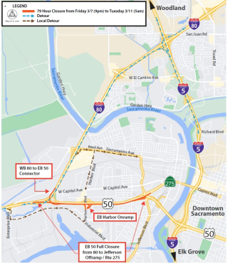
    Official Caltrans map routing Freeway Traffic onto local streets in West Sac

    The essence of Thursdays Caltrans press release is simple, but its repercussions to hundreds of thousands of people are wider ranging: “I-50 east bound to Sacto in West Sacramento will be 100% closed (after the split) for 3 1/2 days, from Fri. 3/7 9pm to Tues. 3/11 5am.

    Its impacts will be felt by hundreds of thousands of travelers- including Sac airport users from Yolo/Solano now facing congestion on I-5 causeway, workers on Monday, and of course Tahoe vacationers on Friday & Saturday. Those dependent on the bus will also be affected:

    80,000 cars cross the Yolo causeway– each direction — every day.

    There will also be an impact on local travel inside Davis, West Sacramento, and Woodland.  Local residents can expect cut thru traffic delays as, traffic is likely to backup over the causeway deep into Davis and traffic will cut up Pole Line and 113 and backup the I-5 Causeway to the airport as has happen on other occasions. And of course south Mace in Davis will likely be effected.  West Sac travel on West Capitol and Industrial & Jefferson will be “affected” as they parallel the closed freeway section- as will Yolo buses that use this segment.


    (more…)

  • Volunteer at the Community Mercantile in Davis, California!

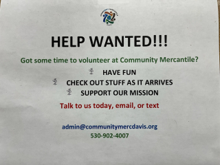
    IMG_0144(From press release) Are you passionate about the environment and eager to make a difference in your community? The Community Mercantile in Davis, California, is looking for dedicated volunteers like you!

    Join Us in Our Mission

    At the Community Mercantile, we believe in the power of reuse and recycling. Our goal is to divert items from the waste stream and give them a second life, reducing environmental impact and promoting sustainability. We need community-minded individuals who share our vision and are ready to contribute to this important cause.

    How You Can Help

    (more…)

  • Sierra Club Yolano Group Comments on Village Farms DEIR

    The following comments were emailed by the Sierra Club Yolano Group to Dara Dungworth, Principal Planner City of Davis Department of Community Development, on Feb 25. 2025, concerning the Village Farms DEIR. (See https://newdavisite.wordpress.com/2025/02/02/draft-eir-for-village-farms-released-for-public-comment/).

    1. Alternatives

      a) Recommend Consideration of Co-op Housing – Evidence suggests that a housing co-op model can provide stable, affordable workforce housing for individuals and families (see California Cooperatives: Today's Landscape of Worker, Housing and Childcare Cooperatives). Providing affordable local housing for people currently commuting to Davis from outside Davis will lessen the VMT and GHG emissions impact of this project and should be considered as an effective mitigation measure.

      We recommend that the FEIR analyze as a Project Alternative a co-op model (perhaps similar to Dos Pinos or Muir Woods) as a supplement to the proposed starter-home program to explore the environmental benefits that such a model could produce.

      b) Recommend Consideration of Alternative Only Below Channel A – On December 8, 2023, the County of Yolo Planning, Building, and Public Works Departments sent a letter to the City of Davis commenting on the Village Farms NOP which stated, "The Draft EIR should consider a reduced footprint alternative that defines the northern project boundary south of the existing Davis Drain and explores the opportunity for increased density, thereby maximizing housing options without compromising economic returns". Quoting from Cal. Code Regs. Tit. 14: "Because an EIR must identify ways to mitigate or avoid the significant effects that a project may have on the environment (Public Resources Code Section 21002.1), the discussion of alternatives shall focus on alternatives to the project or its location which are capable of avoiding or substantially lessening any significant effects of the project, even if these alternatives would impede to some degree the attainment of the project objectives, or would be more costly. "

      We similarly recommend that a reduced footprint alternative be examined with its northern project boundary south of the existing Davis Drain to determine if building 1,000 or more units on such a reduced footprint can provide increased density and maximize housing options while preserving more trees and habitat and still meeting project objectives.

    (more…)

  • City admits liability for killing woman in Park

    By Alan “Lorax” Hirsch

    On February 23, 2021, a mother, Jennipher Comey,  was struck, pinned down and killed  by a failed city tree that stood beside the  sandbox in Slide Hill Park in east Davis. As also reported in the Enterprise Sunday, the event occurred  in front of her 3 year old daughter Marjory.   Two weeks ago, after four years, the city admitted its inadequate tree care, and thus liability. This admission only seems to have occurred after an under-oath deposition by the former city arborist of the time. Robb Cain. He stated there was no city record of this tree ever being pruned in past, no current plan to ever inspect it for safety- or any future schedule to even do any routine tree maintenance  pruning in the Slide Hill Park.  This according to Davey Resource Group lawyer, a codependent in the case and the company the city hired to do the city’s $250,000 urban forest master plan (UFMP) later in 2021.

    In contrast, professional arboriculture “standard of care” practice calls for paying heighten attention to trees that overhang a children’s play area or picnic tables- as the fallen one did.  Slide Hill Park’s trees were ignored, not even on the city’s minimal 7 year “block pruning” cycle street trees get according to Davey.

    The delay in admission meant the city seems to have made no payment to support the family over the last four years since the incident. During that period the now orphan girl and her surviving father left Davis and moved to Ohio to be near family for support not received in Davis.

    (more…)

  • The Gravel Mining Companies Operating Adjacent to Cache Creek are Continually Violating Numerous Provisions of the Yolo County Surface Mine Reclamation Ordinance

    The following was emailed to Stephanie.Cormier@yolocounty.gov and clerkoftheboard@yolocounty.gov on Feb 7, 2025 with a request that the memo be forwarded to the Planning Commission and the Board of Supervisors

    From:  Alan Pryor, Chair – Sierra Club Yolano Group
    To:       Yolo County Planning Commissioners
    Date:   February 7, 2025
    Re:       The Gravel Mining Companies Operating Adjacent to Cache Creek are Continually Violating Numerous Provisions of the Yolo County Surface Mine Reclamation Ordinance

    On behalf on the Sierra Club Yolano Group, attached please find a report in which numerous violations of Yolo County’s Surface Mining Reclamation Ordinance are disclosed and documented.   Download Yolo County Gravel Mining C

    Further, these violations were not disclosed last year to the Planning Commission when it was charged with certifying the 2023 Annual Compliance Report regarding off-channel gravel mining as required by County Code.

    Instead, as explained in the attached report, false representations that all of the mining companies were in compliance with the provisions of all applicable mining ordinances in the State and Yolo County were made to the Planning Commission in Findings of Fact statements.

    The ongoing failure by the County to enforce the provisions of the applicable mining ordinances in Yolo County has resulted in continued production and bioaccumulation of methyl mercury to excessive levels in fish in most of the impoundment pits on the mining sites and required Lake Management Plans to remediate the problems have not been implemented. These compliance shortcomings have also resulted in the ongoing failure by the mining companies to fully restore formerly mined farmland back to its pre-existing soil quality and crop productivity. 

    This is fully explained in the attached report entitled, “Yolo County Gravel Mining Companies are Continually Violating Numerous Provisions of the Surface Mining Reclamation Ordinance_2-7-25”.

    We request that the Planning Commission refrain from wrongfully certifying that mining companies are in compliance with Yolo County mining ordinances in the future. We additionally request that the Planning Commission not permit or entitle any future new mines or extensions or expansions of existing mines in Yolo County until such mining companies are in full compliance with all existing ordinances.

    Toward that end,  we ask that the following questions be addressed with detailed written answers.

    (more…)

  • Draft EIR for Village Farms released for public comment

    Screen Shot 2025-02-02 at 3.24.20 PM
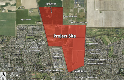
    The project site is bounded by Pole Line Road to the east; East Covell Boulevard to the south; the Union Pacific Railroad (UPRR) mainline, F Street, and Cannery development to the west; and Davis Paintball, Blue Max Kart Club, and agricultural land to the north.


    By Roberta Millstein

    On January 7, the City of Davis released the Draft Environmental Impact Report (DEIR) for the Village Farms Davis Project for public review.  The approximately 497.6-acre project site is located north of East Covell Boulevard, east of F Street, and west of Pole Line Road in a currently unincorporated portion of Yolo County, California.  The City has invited public comment on this document for a 45-day period extending from January 7, 2025 through February 25, 2025. (Sorry for the late notice, but there is still time to submit comments).  EIRs are part of the California Environmental Quality Act (CEQA) process.

    The DEIR materials can be found within the ‘CEQA Documents and Information’ tab at: https://www.cityofdavis.org/city-hall/community-development/development-projects/village-farms-davis

    It's a very long document, but citizens can start with:

    And then, you can peruse particular areas of interest or concern:

    (more…)

  • Update on Suisun City’s Council Meeting on Expanding City Boundaries and Exploring Land Annexation

    SolanoMap

    By Nate Huntington
    Solano Together Coalition Member

    Thank you to those who showed up last week at the Suisun City Council meeting to voice your concerns about the discussion on expanding city boundaries and exploring land annexation.  

    In Short: Last Tuesday, January 21, the Suisun City Council voted 4-1 to “provide direction to staff to explore strategic opportunities for expanding Suisun City’s boundaries and advancing the goals outlined in the Resiliency Plan.”

    Right before the meeting, Solano Together sent out an action alert urging supporters to attend and voice their concern for the lack of government transparency and the intention to expand boundaries into parcels in the Sphere of Influence—defined as a boundary that shows the probable future service area and physical boundaries of a local agency. We also had representatives in attendance for public comment.

    (more…)

  • URGENT: Attend Suisun City Council Meeting Discussion on Expanding City Limits


    Map

    Suisun City, Suisun City’s sphere of influence and Flannery Associates land parcels. Map by Solano Together using QGIS. Datasources: OSM Standard, MTC/ABAG Data Library, Solano County parcel data


    Nate Huntington 
    Solano Together Coalition

    This Tuesday, January 21, at 6:30 p.m., we urge you to attend the City of Suisun Council Meeting, where there will be a discussion on potentially expanding Suisun City limits.

    What? Suisun City Council Meeting
    When? TODAY – Tuesday, January 21, at 6:30 p.m.
    Where? Suisun City Council Chambers, 701 Civic Center Boulevard, Suisun City, CA – or
    Zoom Meeting Information:
    Link: https://zoom.us/join
    MEETING ID: 829 2890 4906
    CALL IN PHONE NUMBER: (707) 438-1720

    WHY IT'S IMPORTANT

    Late Friday evening, the City of Suisun City released the agenda for today’s City Council meeting. Agenda item number 17 is inconspicuously titled, “Vision for Suisun City: Building Resilience and Expanding Opportunities.” This appears to be a plan by the City of Suisun to annex land owned by California Forever and work with them to develop outside of existing city limits. California Forever is continuing their secretive, behind closed doors approach even after committing to a public process.

    In the agenda packet, starting on page 179, the item discusses the city’s economic “Resiliency Plan” and suggests “the Resiliency Plan’s ultimate success depends on increasing the city’s population and strategically expanding its boundaries.”

    (more…)